 Ngau Chi Wan Village is located on the eastern Kowloon Peninsular, facing Kowloon Bay and old Kai Tak Airport in the south, Fei Ngor Shan at the back in the north and Lion Rock Hill in the west. It was a farming village of Hakka dialect and was near the waterfront. The population was over 200 in early days.
 Ngau Chi Wan Village was one of the 13 villages of Kowloon and is a few old village left in the urban areas. It has a history of 200 years. Kwun Tong Road was the main transportation route whereas Clear Water Road and Hammer Hill Roads all started at Ngau Chi Wan Village.
My early childhood was spent in Ngau Chi Wan Village and had witnessed the implication of urbanization on the changes of many places and villages. The major change in Ngau Chi Wan Village was envisaged in the use of the village farmlands for the building of the Choi Hung Estate and the houses on the front portion of the village were demolished for the building of the Choi Hung Station of the mass transit underground railway (MTR).
In 1992, I returned to Hong Kong and bought some old photos of Ngau Chi Wan from the Hong Kong Lands Department to reminisce the old village of my early childhood and to view the changes of the vicinity. In December 2012, I visited Ngau Chi Wan Village again and accomplished this album for reminiscence.
---------------------
Photo equipment:
Nikon D300s, Nikon GP-1 GPS
AF-DX 18-200mm f/3.5-5.6
=============================
我的童年在牛池灣渡過,見證了都市化對各地方及鄉村的改變。其中對牛池灣影響最大的是政府將牛池灣村前的一大片菜田規劃出作興建大型屋邨的地皮,也清拆部份村屋而興建香港地下鐡路線的彩虹站。
1992年初次返港,在香港地政署買了一批早年牛池灣的高空鳥瞰照片,可以譲我重溫童年牛池灣及附近地區的環境變化。最近重返牛池灣村,拍了這輯照片。
 |
| An air-view photo of Ngau Chi Wan, Diamond Hill and Kai Tak Airport taken on 27th December 1956. The farmland of Ngau Chi Wan Village was planned for the building of a residential estate (white portion in the middle). 1956年12月27日高空拍攝的牛池灣村、鑽石山區及啓德機場。牛池灣村前的菜田已劃出開發大型屋邨的地皮(中間白色部份)。 |
 |
| Air-view photo of Ngau Chi Wan Village and Choi Hung Estate taken on 25th April, 1979. The semi-circular buildings on the lower left were army barracks. The bus station of early days was located on the road side. 1979年4月25日彩虹邨的高空照片。半圓形的軍營在彩虹交滙處下方。早年的巴士總站設在這裡的路旁。 |
 |
| An enlarged photo of Ngau Chi Wan Village (cropped from the above photo) 牛池灣村放大圖 (裁剪以上照片) |
 |
| Ngau Chi Wan Village in 1963. My house is on the upper right corner whereas the small village office is on the left of the photo. (archive photo) 1963年的牛池灣村, 我的故居在右上角﹐ 鄉公所在照片左面。(檔案照片) |
 |
| Ngau Chi Wan bus station in 1953. Bus route #14 to Jordan Ferry Pier. Bus route #9 to Tsim Sha Tsui. All were double deckers. Still remember taking bus here with mom to Jordan Ferry Pier. (internet photo) 1953年牛池灣巴士總站,當年14號從牛池灣往佐敦道碼頭,往尖沙咀的是9號巴士,巴士總站設在這裡,巴士都是雙層的。仍記得童年時隨母親在這裡乘車往佐敦道碼頭。(網絡照片) |
 |
| Left: Ngau Chi Wan bus station on Kwun Tong Road in 1953. Right: Photo of Lion Rock Hill and Choi Hung Transit Interchange taken on the upper deck of a bus in 2010 左:1953年的官塘道牛池灣巴士站。右:2010年在巴士上層拍攝獅子山及官塘道彩虹交滙處 |
 |
| An old stone house built in 1927 was behind my house. It still has the look of an ancient house. 我童年居所後的百年古屋,色褪古樸濃。 |
 |
| The original sliding door of wooden poles was replaced with a steel sluice-gate 原來是推拉橫木的大門已改用鐵閘 |
 |
| The weathered old house 古屋已露風霜 |
 |
| A close shot of a row of stone blocks for an old ditch which had already been filled up. 古屋前的一行石墪 |
 |
| A narrow lane-way between houses 屋與屋之間的小巷 |
 |
| Village seen behind the red flowers 村屋掩映在紅花後 |
 |
| A panorama view of the "Grant Emperor's Hall" 「大王宫」全景 |
 |
| The shrine of the Old God of Lands in the village 村內的「土地公」 |
 |
| Many village boys were playing around here 小童嬉戲遊玩的小巷 |
 |
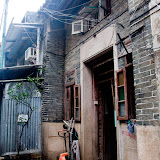
| Part of a village scene 村內一隅 |
 |
| The outside view of the village restaurant. The Choi Hung Station of the MTR was built just underground of the open area where some of the village houses were demolished. 茶樓外貌,右面空地是昔日村屋所在位置,為興建彩虹地鐵站而清拆,當年採用從地面往下挖土法建地下彩虹站,完成後在地面鋪土。空地下是彩虹地鐵站。 |
 |
| The village office was built in 1950 建於1950年的牛池灣鄊公所 |
Click for more photos 點擊更多照片》
View Ngau Chi Wan Village in a larger map
牛池灣村亦是我童年曾到過的地方,記憶中陪伴同學回家時經過一條水坑,再經過一排像是鄉公所的古老屋,常跟同學向一位看來是街坊保長的老伯打招呼,我們稱呼他為:[能伯],跟著別過頭來偷笑,老伯覺得理所當然,個名係咁,慣哂。晚上條村好少街燈,非常黑暗,外來人好少入村。牛池灣村的變化亦是相當大,不知香港政府古物保護署有否將之列入受保護古蹟?
ReplyDeleteHi, Peter, All the best to you in the new year. Thanks for your blog wherein we enjoy your photos and often share your feelings of nostalgia.
ReplyDeleteThank you for photos.
ReplyDeleteevery day dinner here !!
ReplyDelete我小時都住牛池灣
ReplyDeleteHi Peter! I am writing an article about the history of Ngau Chi Wan for the South China Morning Post. I would love to talk to you about your childhood in the village. Could you contact me at christopher.dewolf@gmail.com? Thanks!
ReplyDeleteHi Christopher! Yes, I am happy to do that for your article. As I am now a musician and will be terribly busy with musical performance and events in daytime , I prefer to have the phone interview after 12:30am in Toronto time. Cheers!
DeleteChris , is the article published on SCMP yet, I would like to read it.
ReplyDeletePeter, I used to live in Ngau Chi Wan East before 1976 . Please contact me via email unis369@gmail.com so we can share some childhood memory.
ReplyDelete秋記,萬佛堂,永樂洞,曾华生李昌-真善美理髮店, 芝麻廠 hope to recall your memory
ReplyDelete